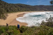
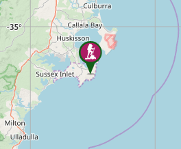
Steamers Beach is a surf beach accessed by a rough 4WD track, which can also be combined into a longer circuit. A nice and relatively secluded beach. The high, vegetation-covered sand dunes behind the beach are a result of a “mega tsunami” which occurred around 6700–7000 BC.
Getting there
Steamers Beach carpark, accessed via Jervis Bay Road, Wreck Bay Road and Stony Creek Road, through Booderee National Park
Maps
Sussex Inlet 9027-4S (1:25,000).
Route/Trail notes
A wide and sandy 4WD trail (closed to vehicles) is clearly marked at the Steamers Beach car park, which continues in a southerly direction towards the coast. The last hundred metres or so are on a fairly steep and narrow path before the wide and exposed beach is reached.
Permits/Costs
National Park entry fee payable (or annual pass)
Other References
Detailed track notes and photos: https://hikingtheworld.blog/2018/01/18/steamers-beach-jervis-bay/
National Parks web pages: http://www.nationalparks.nsw.gov.au/visit-a-park/parks/jervis-bay-national-park
GPS Tracks
- No GPS available for this walk yet.


 6.3
6.3 2
2
Comments
Nobody has commented on this walk yet. If you've done it then tick it off and add a comment.