Aussie Bushwalking can keep track of your bushwalks.
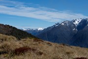
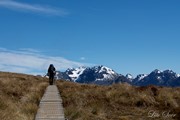
Login/signup to tick this walk off.The Kepler Track is a 60 km, 3-4 day loop track taking you from the gentle, beech-forested shores of lakes Te Anau and Manapouri to the tussocky alpine tops and grand Mt Luxmore. Your reward for the hill climb is a long section above bushline with marvellous panoramic views of the Kepler Mountains on one side, and lakes, rivers and hanging valleys on the other.
The Kepler Track is an excellent track for you and your family and friends, especially if you love the outdoors, want an adventure with a bit of a physical challenge that is not too hard to get to and has excellent facilities.
This is a Great Walk and offers a high standard of track and very comfortable, serviced huts as well as camping opportunities. During the winter months (May to October) the Kepler Track remains open, but with reduced facilities.
Getting there
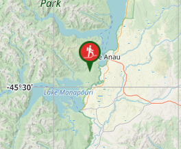
The Kepler Track is circular track that begins and ends at the Kepler Track car park, which is at the southern end of Lake Te Anau, about 5 km from Te Anau township.
Access is either by road or a 50 min walk from the Fiordland National Park Visitor Centre. Alternatively, there is an entry point at Rainbow Reach, a 10 min (12km) drive from Te Anau.
Shuttle buses provide a daily service to entry and exit points on the track during the Great Walks season (late October to late April). A scheduled boat service also offers transport to Brod Bay.
Maps
The map and profile are available HERE.
Route/Trail notes
Te Anau to Kepler Track carpark
45 min, 2 km
Start your journey on the lake side path outside the Fiordland National Park Visitor Centre. Passing the Te Anau Wildlife Park, continue around the shores of Lake Te Anau to the Kepler Track carpark near the Lake Te Anau control gates, where there are toilet and picnic facilities.
Kepler Track carpark to Brod Bay
1 hr 30 min, 5.6 km
The track follows the lake shore through forest of mountain and red beech, with kamahi and some scattered rimu and miro. After passing an attractive grove of hard tree ferns and crown fern, Dock Bay is reached. Continue across the Coal Creek Bridge and follow the lake shore to Brod Bay. Brod Bay is a delightful place to swim and camp if you have had a late start. There is a shelter here, with tank water, picnic tables and two toilets. See Kepler Track: Carpark to Brod Bay.
Brod Bay to Luxmore Hut
3 hr 30 min - 4 hr 30 min, 8.2 km

Luxmore Hut
From Brod Bay the track climbs steadily for about two hours to limestone bluffs – an ideal lunch stop. After another hour’s climb the bush line is reached, providing panoramic views of the Te Anau Basin, Takitimu Mountains, and the Snowdon and Earl Mountains. Luxmore Hut (1085 metres) is about a 45 minute walk from the bush line. This part of the track is marked by orange-topped snow poles, which are helpful in poor weather conditions.
Side trip - Luxmore Cave
The cave is a 10 minute walk from the hut and is clearly signposted. Please indicate your intentions in the visitors' book provided in the hut when visiting the cave. Each person should take a minimum of two light sources.
Luxmore Hut to Iris Burn Hut
5 - 6 hr, 14.6 km
In heavy rain, strong winds or wintery weather, wait at Luxmore Hut until the weather improves.
The track climbs gradually from the hut to a ridge just below the summit of Mount Luxmore. A 10 minute side trip to the summit (1472 metres) provides stunning panoramic views in fine weather. The track then descends to a shelter close to Forest Burn Saddle, where there is a small day shelter and toilet.
Beware of wind gusts when crossing the saddle.
The track sidles, climbs and follows a ridge system for about two hours to Hanging Valley Shelter. It then follows a long, open ridge toward the Iris Burn and descends through a series of zigzags into a hanging valley. The track winds its way through beautiful forest, with good views of a large natural landslide.
The Iris Burn Hut (497 metres) is sited in a large tussock clearing. From Iris Burn Hut, a 20 minute stroll leads to Iris Burn Waterfall.
Iris Burn Hut to Moturau Hut
Kepler Track in winter
5 - 6 hr, 16.2 km
Today is a steady day’s tramp through beech forest and a gorge, generally following the Iris Burn. The track climbs over a low saddle and wanders through mixed species forest to a large slip, formed during heavy rain in January 1984.
About 2½ hours from the Iris Burn Hut is a work camp for track maintenance. Rocky Point Shelter is located just around the corner and is a good place for a lunch stop.
Below Rocky Point the track sidles through a gorge, coming out on river flats near the mouth of the Iris Burn. Nearing Lake Manapouri, the track turns left through lowland beech and podocarp forest. It follows the lake shore to Moturau Hut, situated beside a beautiful beach, with panoramic views of Lake Manapouri.
Moturau Hut to Rainbow Reach
1 hr 30 min - 2 hr, 6 km
The last day is a moderate stroll through beech forest to Rainbow Reach. The track crosses a wetland and the meandering Forest Burn, just above its outlet into Balloon Loop, an old part of the Upper Waiau River.
It then follows the Waiau River terrace to the swingbridge at Rainbow Reach. Walkers are able to catch a shuttle bus service to Te Anau from here.
Rainbow Reach to Kepler Track carpark
2 hr 30 min - 3 hr 30 min, 9.5 km
The track up river from Rainbow Reach is well worth walking for the variety of forest and river views. This section provides good opportunities for trout fishing and leads back to the Kepler Track carpark. See Rainbow Reach to Kepler Track carpark.
Kepler Track carpark to Fiordland National Park Visitor Centre
Return to Te Anau along the track from the Kepler Track carpark, through the Te Anau Wildlife Park, to the Fiordland National Park Visitor Centre.
Permits/Costs
Summer season (29 October 2013 to 30 April 2014) - $54/night for a hut per person, $18 for a campsite per person.
Other References
Official page of the track is accesible HERE.
GPS Tracks
- No GPS available for this walk yet.


 60
60 4
4
Comments