


 4.5
4.5 90
90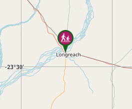
Aussie Bushwalking can keep track of your bushwalks.
Login/signup to tick this walk off.Thompson River Floodplain Walk
Central Queensland
Menu
This walk in Longreach is from town to the Thompson River through the floodplain along a disused road. The end of the walk is then along a current road and takes you to the Thomson River. Return via the same path.
Picnic Facilities
Toilets
Dogs Permitted
Arid or Desert
Getting there:
Begin the walk off the Landsborough (Matilda) Highway opposite Kingfisher Street.
Maps
None found.
Route/Trail notes:
Follow the sealed path along the side of the road which takes you to a disused road. This road takes you over a bridge before reaching a current road which leads to the Thomson River. Return via the same route. This walk is best done early morning or late evening due to the heat. This is a very popular walk in Longreach.
Permits/Costs
None.
Other References/Comments:
None.
GPS Tracks
- No GPS available for this walk yet.
Comments