Zamia Walk

Central Queensland

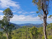
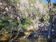
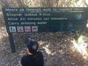
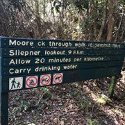
Start walk from German Street car park which is unsigned. The trail begins from the carpark heading east behind the houses with creek on right-hand side. At end of housing estate is a creek crossing and sign for the park. Walk another 1-2 km until you reach another park sign and a metal post indicating the start of the walk. The path is well defined throughout although overgrown in parts. For the next 6km the path will hug the side of Moores Creek with multiple creek crossings. Take care not to lose the path when crossing the creek in the upper reaches. There is also a nice forest to walk through before the main ascent starts which has a lot vegetation when climbing the side of the mountain. Once you lose the main branch of the creek (about 7-8km) the trail will begin to ascend the mountain and cross some smaller branches of the creek with small waterfalls. The trail will then reach a ridge and subsequent lookout point with grass trees all around and view of the Beserker Ranges. The ascent is then quite easy from this point on with plenty of opportunities to take a break with rest chairs available. The walk can be frustrating at time as it follows the creek right around the base of mountain before it commences an ascent. It also has multiple minor ascent and decents on the base of the mountain which hug the creek. You think you are going to ascend only to find another creek crossing. The creek is usually flowing and very clear giving you the opportunity to fill your water bottle up at refresh at various stages before the full ascent commences. The trail is also very rocky in parts when following the creek so a high degree of care must be taken not to roll an ankle. This a challenging and sometimes demanding hike so leave plenty of time to complete. Their are plenty of signs to help you find the way from the middle section of the hike onwards which help hikes descending. Take plenty of water for this hike as it is a very humid climate. Parks recommend this climb as descent only. It is also deemed a one-way trail.

591m
Maximum Elevation
548m
Total Climb

GPS Tracks

Comments

Lovely local walk. The creek was dry this time of year. We hiked up and back and did a couple of side tracks, about 30km. 3.5 hours up, 3 down at a stop and look at the view pace. Towards the top you can see the ocean over towards Joskeleigh in one direction, the volcanic plugs in another, and the hills all around.

I'm guessing it gets hot in summer but there might be more water then. It was about 7 degrees when we started and felt like about 25 when we finished.

sk on 17 Jul, 2020

I ran/hiked up this trail in 2 hours. I did a couple of km's extra at the start and finish of the actual trail, then got someone to pick me up from the top of Mt Archer. My total distance was 15km. Without the small add ons it would be about 12/13km with 700m elevation. The last 3km contained 300m elevation. A little overgrown in parts but a nice trail. As I was starting at the bottom a couple of girls were just finishing their hike down. They had a big stick completely covered with a ball full of spider webs. I think they may have made my run a lot more pleasant by clearing our all the spider webs for me. :)

ak on 28 Dec, 2017

Having only one car we decided to start at the bottom and work our way up, knowing that the descent would be easier. It took us 4 hours to go up and 3.5 to come back down. The Creek was flowing quite high and we started the walk taking our shoes off to cross as too many rocks were under water. However after doing that four times we gave up and wore our shoes through the water as it was taking too long. Just before the top it started raining and it rained most of the way down. It really wasn't a problem though. It was really quite refreshing. We sure did feel our muscles afterwards.

Ian and Sue on 21 Oct, 2017

Lovely hike, but definitely earned a long bubble bath after.

Rhiannon Brooks on 17 Sep, 2017

Comments on main page.

Badger on 8 Apr, 2013

A very hard walk especially in the warmer months. Take heaps of water and snacks, allow extra time for breaks.

Saffy_26 on November

Where

Click here to load this map.

Nearby Walks

Done this walk?

This walk has been ticked 12 times

Aussie Bushwalking can keep track of your bushwalks.

Login/signup to tick this walk off.

Tick walks to keep track of where you've been. You must Login to tick walks. Accounts are 100% free so sign up if you don't have one.