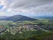
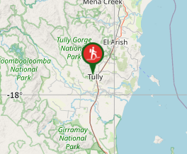
Based in Tully Gorge National Park. This is a steep hike to the top. Watch out for bladed or needled plants. Great view of Tully and the surrounding sugarcane fields. You can see the ocean from the top.
Getting there
At the end of Brannigan Street, There is a little Info shelter. It says to sign in no harm in not doing it. From there the path is reasonably outlined, passing the side of a house leads you to the start of the rainforest and up you go.
Maps
See "Mount Tyson Walking Track Map.pdf" at the following link:
https://parks.des.qld.gov.au/parks/tully-gorge/
Route/Trail notes
It's a steep and muddy climb. Tully gets the most rain in QLD so don't expect it to ever really be dry. It's 2.5km to Scouts Rock lookout. Some will be statisfied with just getting here. However if you want to top the mountain than continue further (this deffenitly isn't as much walked compared to getting to the look out. Once at the top, views can be hard to find due to dense rainforest. Scrambling/climbing on the rock faces might get something but not as great as the lookout before. One the way down watch your step, hold vines and aviod sliping.
Permits/Costs
N/A
Other References
How can I find more info? Any guide books?
GPS Tracks
- No GPS available for this walk yet.


 6.4
6.4 3
3
Comments