Toohey Forest to Mt Gravatt

Brisbane City Council Local Walks

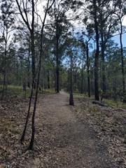
The track is paved then bitumen to wide track. This walk can be completed in almost all conditions.

Lookouts
Picnic Facilities
Public Transport

Getting there

Brisbane city council buses go past Toohey Forest. Carparking available

Maps

Available for download from Brisbane City Council website

And GPS walk details availble online at google maps

Route/Trail notes


Permits/Costs

No permits required. no camping in park

Other References


GPS Tracks

  • No GPS available for this walk yet.

Comments

I discovered this walk online at Brisbane City Council website when I was looking for a local park with BBQ's.

Start from the Toohey Forest and go along Toohey Ridge track until you reach the SE freeway then walk along side the freeway briefly downhill towards a tunnel. Which is part of the Inter Campus Link track.

Continue along this track under the M1 highway and up the hill. You will reach Messines Ridge Road (hope i got the spelling correct) turn right towards Circular Drive round-a-bout go straight ahead (left) and walk along the pathway and or side of the road where safe.

Keep walking past the small cooling towers and follow the track left to Mt Gravatt (mountain).

Keep following the signs to Mt Gravatt Lookout. Amazing views of Brisbane CBD skyline from here. and other areas

This is a great spot for lunch.


Then return same way. Have fun.

Boris Zoubakin on 1 Mar, 2010

Great walk.

Adam on 1983

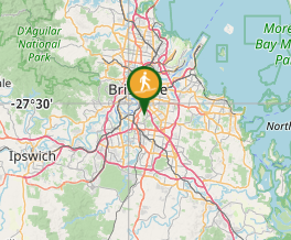
Where

Click here to load this map.

Nearby Walks

Done this walk?

This walk has been ticked 103 times

Aussie Bushwalking can keep track of your bushwalks.

Login/signup to tick this walk off.

Tick walks to keep track of where you've been. You must Login to tick walks. Accounts are 100% free so sign up if you don't have one.