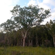
Adjoining the Mooloolah River, the Mooloolah River National Park protects valuable remnants of coastal lowland habitat, rainforest, open eucalypt woodlands, melaleuca forests, wallum banksia woodlands, scribbly gum open forests, wallum heath and sedgelands.

No Dogs Permitted
No Horses Permitted
No Cycling Permitted
No Trail Bikes Permitted
No Camping Permitted
Swamp or Wetland

Getting there:

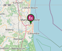
Take the Kawana Way exit off the Sunshine Motorway. To your right, you will see a rough off-road track that runs along the edge of the Park. At 1.5km there is a distinct entrance into the Park. 

Map:

http://www.npsr.qld.gov.au/parks/mooloolah-river/about.html

Route/Trail notes:

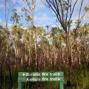
This clearly defined trail cuts south and then travels west to meet with the Boronia Trails and back.

Permits/Costs:

None

Other References/Comments:

You can extend your walk by doing a full circuit. When you meet the Boronia Trail, turn north and then east along the Littoralis Trail to your start point.

Comments

Close to home (and Anaconda!), this is an area we had not previously visited. Originally described as 'wheelchair friendly', it was obviously not unless you had sand tyres: (I have changed it to 'Easy'). There are very few highlights, except for the occasional goanna, but a good trail for a bit of exercise. There was also a sign for the Robur Fire Trail at the start of the Boronia Trail, but not investigated, but presume that it follows the edge of the NP to the river?

F.A.B. on 17 Feb, 2017

We took the turnoff for this walk from the Boronia track.

Ian and Sue on 22 Nov, 2014

Did the whole circuit , Boronia Aemula Littoralis and Melaleuca Trail ( they are connected quite easy )

J on 27 Sep, 2014

Where

Click here to load this map.

Nearby Walks

Done this walk?

This walk has been ticked 18 times

Aussie Bushwalking can keep track of your bushwalks.

Login/signup to tick this walk off.

Tick walks to keep track of where you've been. You must Login to tick walks. Accounts are 100% free so sign up if you don't have one.