Menu
An interesting longer walk that can be done in two full on days or easy three days.
Getting there
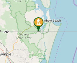
The walk can be started from Elanda Point in the southern end or near Mt Mellun on the Gympie Rainbow beach road. For this walk I caught a bus to Rainbow Beach and booked the taxi to take me back to Mt Mellun.
Map
The Cooloola Coast Region map was the one I used.
Route/Trail notes
The first days walk started from Melluns Car park and walking 9 km to Neebs Waterhole for an early morning tea. The walk is a gradual descent to Neebs Waterhole and has a protrusion of wild flowers and scribbly gums flowering in spring. After having abreak here follow the firetrail and signs to the Cooloola Way crossing which is about another 9km. There is a steep ascent to the Cooloola Way from the floodplains which you are walking. After crossing this road there is a walk of 5 km to Wandi Waterhole and lunch. You have to branch off the trail to Wandi Waterhole. I found many different types of Honey Eaters in this area. This was an excellent place to camp.
Next day, I left early and walked back to the trail and headed downhill for about 8km getting good views of the Cooloola Sandpatch, there were a few boggy patches here. The trail then joins a 4wd track near the Noosa River and follow this down stream to Harry's Hut. A great spot for a swim.
After leaving Harr's follow the road for 500m and turn left into the forest for a descending walk through paperbark and flooded gums. . There are again a few boggy patches. The trail meets another 4 wd drive track where the signs turn you left. On this stretch is the turn off to Fig Tree Point, Where mosquito repellent is a must. The trail follows along into forest till the bridge crossing at Kin KIn Creek. After this crossing the walk is through open grass and timber areas, where there were mobs of Grey Kangaroos. The Kinaba Centre turn off is also in this section about 2 km from the end. This section is about 16 km long. The end is at Elanda Point where the owners will drive you to Noosa for a hefty fee or arrange for a taxi to meet you.
Permits/Costs .
Camping costs $5 per night at any of the camping places.
Other References
Theere are a number of bush walking books highlighting this walk. Including Take a Walk in South East queensland and Bushpeople's guide to Fraser Isalnd and Cooloola.
GPS Tracks
- No GPS available for this walk yet.


 52
52 2
2
Comments