
Copland Track
South Island NZ


Menu
This popular tramp gives a glimpse of Westland’s spectacular forest, river and mountain scenery, with natural hot pools at Welcome Flat an added attraction.

Note: True left and true right refer to the side of the valley or river when facing and looking downstream.
Warning: When Rough Creek is running high, all unbridged side creeks on the walk will also be running high and you will not be able to cross them safely. Do not start the walk in these conditions. There is a flood bridge across Rough Creek for emergency use to exit the valley (located 45 minutes upstream from the car park).
Cross Rough Creek to the orange marker on the other side then follow the well-formed path through the forest. The track is marked across open areas and river crossings by orange triangle markers. From the confluence of the Karangarua River to Architect Creek, the track alternates mostly between boulder hopping on rocky riverbed and forest tracks, with occasional grassy clearings. Architect Creek is considered to be roughly halfway to Welcome Flat.There are two active landslide areas to be crossed on the track to Welcome Flat Hut. The landslide areas are approximately 30 minutes upstream of Architect Creek, and on the true left of Shiels Creek. Both are signposted. Due to unstable slopes, you will need to take particular care during and just after heavy rain.
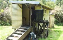
Architect Creek Hut
Beyond Architect Creek the track climbs very gradually towards Palaver Creek as the valley narrows. The climb becomes more noticeable once you have crossed Open Creek. After crossing the Shiels Creek bridge there is a short zigzag to the highest point of the track, after which you descend through forest before emerging at Welcome Flat Hut.
The hot pools are just a short stroll from the hut with fine views of the Sierra Range on a clear day. These pools are a fragile environment so please do not use soaps or shampoo or dig more pools. Always keep your head above the water to avoid the risk of amoebic meningitis.
GPS Tracks
- No GPS available for this walk yet.
 18
18 7
7
Comments
Nobody has commented on this walk yet. If you've done it then tick it off and add a comment.