Aussie Bushwalking can keep track of your bushwalks.
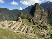
Login/signup to tick this walk off.Beautiful hike past Inca Ruins to reach Machu Picchu.
Getting there
We did a tour for 3 1/2 weeks of Peru. A bus took us to the start of the trail. Train back to Cuzco after the hike. 14hrs of travel to get to Lima which was broken into 3 flights
Maps
Which maps cover the area?
Route/Trail notes
Altitude is the main problem here. Very hilly. Alot of Lungs and Leg training was done before hand. The 2nd day is the hardest and the highest. Day 3 was about 17km of mostly down stairs but we found we could almost run this. Different climates from confortable (1st night) to freezing (2nd night) to very hot on the 3rd night. Camping for each night on the trail.
Permits/Costs
Included with our tour
Other References
The tour group was through Toucan Travel
GPS Tracks
- No GPS available for this walk yet.


 42
42 3.5
3.5
Comments