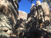
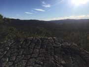
An off track walk from the end of the Underground Creek Trail containing a field of fascinating large stone pillars of various sizes, some of which (Main Pillar) can only be scales with ropes and shackles.
Getting there:
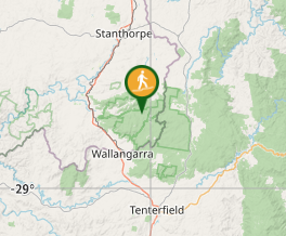
Girraween NP is situated approximately 260km by road south-west of Brisbane. To reach the park, turn off the New England Highway 26km south of Stanthorpe or 30km north of Tenterfield onto Pyramids Road. The winding bitumen road continues a further 9km east through the Wyberba Valley to the park's Information Centre. Continue along the gravel section of the road for a further 3.5km to the Underground Creek car park.
An alternative road from Stanthorpe to Girraween via Eukey and Storm King Dam has some gravel sections.
Maps:
None found. You won’t find this mentioned on any Girraween National Park website.
Route/Trail notes:
From the car park go to Underground Creek where the track continues across a water covered ledge to the right and around the main rock feature. Don’t climb the rock, but head straight out along its side till you cross the fire trail (Peak Trail). From here you head up the gradual ridge until you reach these amazing granite formations. Once you reach the boulders, it is suggested that you circle them anti clockwise. There is no given trail to follow.
Return by the same route.
Due to the creek crossing at Underground Creek it is not possible to complete this walk after heavy rain.
Permits/Costs:
None.
Other References/Comments:
With so many bushwalking options in the park, why not take advantage of the excellent camping facilities at Castle Rock.


 Aztec Temple (GPX)
 5
5 3
3
Comments
Nobody has commented on this walk yet. If you've done it then tick it off and add a comment.