


 Spring Mountain Caldera (GPX)
 14
14 5
5- Spring Mountain (Thornbill Drv trailhead) (White Rock - Spring Mountain Conservation Estate)
- Spring Mountain (Angelica Ave trailhead) (White Rock - Spring Mountain Conservation Estate)
- Frilled Neck Lizard Circuit (White Rock - Spring Mountain Conservation Estate)
- Balancing Rock (Ben Nevis Park trailhead) (White Rock - Spring Mountain Conservation Estate)
- Ironbark Track (White Rock - Spring Mountain Conservation Estate)
Spring Mt Caldera (Thornbill Drv trail head)
White Rock - Spring Mountain Conservation Estate
Menu
GPS Tracks

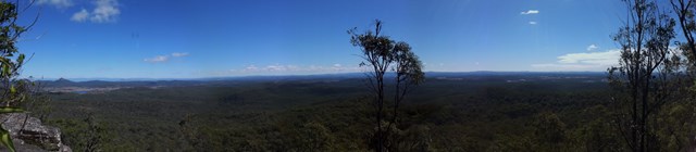


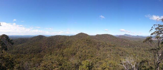

A great walk. Starting at the end of Thornbill Drive, Greenbank. 60 degree views atop Spring Mountain. Caves and cliffs along with some off track navigation along the aptly named Dragons Spine Trail!
Lookouts
Scrambling or Climbing
Navigation Required
Eucalypt Forest
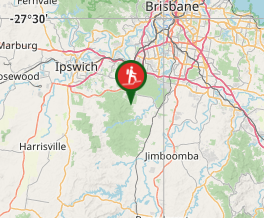
Getting there
From Springfield Greenbank Arterial Rd,Greenbank. At the roundabout take Ison Rd, turn L¡left into Beagely Rd, rightinto Attunga Rd, left into Lyndale Rd which turns into Honeyeater Drive. Left into Thornbill Drive. Park at the water tower at the top of the hill. Walk half way up bitumen drive way start walk on right.
Maps
Sunmap Spring Mt 9442-12
Route/Trail notes
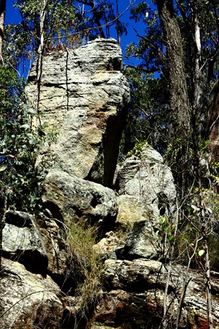
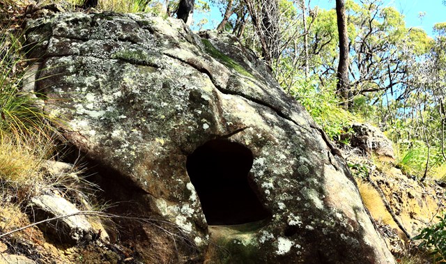
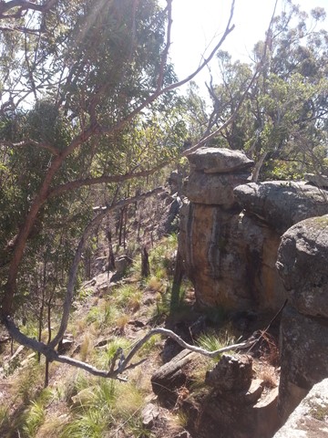
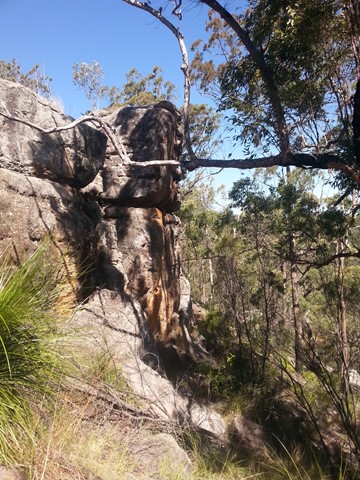
Starts at the water tower at the end of Thornbill Drive Spring Mountain. Follow the right trail half way up the drive of the water tower. Turn Left at a t intersection and follow the track west uphill.On the right is an old concrete water tank known as the ruins. Follow the fire trail to the highest peak you can see,stick to the left of the ridge.At the highest point wind your way to the top of the rocks,a great place to rest and enjoy the view. You can now see the caldera shape that gives this track its name! Continue w through a gate and follow the saddle to the next peak,the track narrows here,At the top of the next rise I call this Beardy,s Camp.Great veiws of the city skyline.Continue untill you break from the bush into a large clear y junction.Back on to fire trails.Follow the trail to the right down hill.(Left will take you to white rock).Pass through another gate on your left is keyhole cave.The next peak is Spring Mt to ascend leave the fire trail and skirt around the base heading sth.the trail appears to end.Start heading up here to a small cave.Skirt left of the cave and pick your way through the boulders till you reach the summit.Dont go to far left if it feels a bit airy head back towards the cave and straight up!Enjoy amazing 360 dgree vews.Take care there are some large and slippery rock faces up here!To descend retrace your steps,back to the fire trail! Follow the trail to the left downhill till you come to a point where the trail drops steeply,look to your right and find the lonely boulder.There is no obvious track here so a little navigation skills will come in handy.I call this" The Dragons Spine Trail ".The next landmark is the point an easy scramble down ,just stay on top of the ridge to get down to a wide open grassy saddle.Follow this stay high L or R of you drops down into gullys.soon you will start to see a rocky ridge heading left follow this , staying as high as you can .You should start to imagine why i call this the dragons spine! As you climb gradually higher the escarpements to the left and right get steeper,These cliffs are big enough to have a serious fall and are coverd in slippery mosses and lichens take care stay on top.On your right you will see a series of rocks which resemble the plates of a stegosaur.Theres a gap between here and the highest point.The best place to scramble down.Make your way to the highest point The T Rex and look south to the escarpment of white rock jutting out from the scrub! Retrace your steps 20 m or so to the Stegasaur and scramble down through a gap in the rocks.1 level,and keep t rex on your left.you can climb under this formation here.Continue uphill from here up some bouldery skree Always staying high.Drop gently off this plateu into a grassy saddle,follow the ridge untill it rises to a scrubby plateu,stay up untill you come out at the fire trail again beside the highest electricity tower.Follow this track to the right weaving your way down hill to the bottom of a gully and a track intersection,go right.you will cross a creek and come across a spring mt gate on your right.You can go back this way but i keep going to the next gate #6.Turn right here and head steeply up hill.At the top of the hill the track seems to head left stay right.At the next junction stay left.The track on the right heads back down to the spring mt gate you passed before gate 6.You are now on the track back to where you began ignore any L or r trails till you see the spring mt forest park sign take the next left when you can see the wate tower back to thornbill drve.
GPS Tracks
Where
Click here to load this map.
Comments