- Mt Rufus (Cradle Mountain-Lake St Clair National Park)
- Narcissus Hut to Cynthia Bay (Lakeside Walk) (Cradle Mountain-Lake St Clair National Park)
- Fergy's Paddock Loop (Cradle Mountain-Lake St Clair National Park)
- Platypus Bay (Cradle Mountain-Lake St Clair National Park)
- Pine Valley (Cradle Mountain-Lake St Clair National Park)
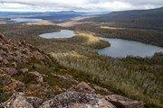
A panoramic view of Lake St Clair, Mt Olympus, Mt Byron and Mt Hugel from the top of a rocky peak. A lesser-walked track but one that combines great views with some alpine lakes and rainforest areas.
Getting there
Starts/finishes at Lake St Clair Lodge (Cynthia Bay). Approx 2:15hrs from Launceston and 2:30hrs from Hobart.
Maps
4233 Rufus 1:25K (south end of lake)
TASMAP Lake St Clair Day Walk Map (print & digital options)
Route/Trail notes
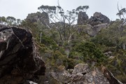
Follow the Watersmeet Nature Walk to Watersmeet where the Cuvier and Hugel Rivers meet. Turn left and follow the signposted track to Shadow Lake. The track winds through rainforest and across a bridge over the Hugel River. At Shadow Lake take the Hugel Track past Forgotten Lake (from the lake the track is sometimes wet and muddy). The track turns uphill through a forest of pandani, myrtle, deciduous beech and snow gums. The last section of the track is steep, up across a cairned route on boulders and scree to the summit
Permits/Costs
National Park entry fee payable.
Other References
https://hikingtheworld.blog/2019/01/06/mt-rufus-and-little-hugel/#Little-Hugel
Lake St Clair Day Walks Fact Sheet - https://www.parks.tas.gov.au/file.aspx?id=19307
GPS Tracks
- No GPS available for this walk yet.
Where


 ??
?? ??
??
Comments