
Mount Field East via Seagers Lookout & Beatties Tarn
Mount Field National Park


Menu
A lovely loop taking in the major features of the east side of the plateau.
Lookouts
Scrambling or Climbing
Alpine
1274m
Maximum Elevation
566m
Total Climb

Getting there
How do you get to the start of the walk?
Mt Field East Carpark on Lake Dobson Rd
Maps
Which maps cover the area?
Maps of Mount Field National Park
Route/Trail notes
A detailed description of the walk!
Head up hill to Seagers Lookout then return to the main path and follow it out to the Mount Field East turn off. After bagging the summit drop down off the plateau to Lake Nicholls before continueing to the short side trail to Beatties Tarn. Shortly after you will reach the pack track which will take you up the road to the start point.
Permits/Costs
Do you need any permits? What's the cost?
Free if you already have your parks pass
Other References
How can I find more info? Any guide books?
GPS Tracks
- No GPS available for this walk yet.
 11.1
11.1 4
4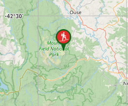
Comments
Nobody has commented on this walk yet. If you've done it then tick it off and add a comment.