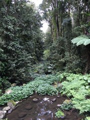
Helmholtzia loop walking track takes you on a short, easy walk through a beautiful section of Border Ranges National Park. It takes you across pristine Brindle Creek on low bridges and into World Heritage rainforest.
The name of this track comes from the helmholtzia plant that grows in the area. Also referred to as the stream lily, this rare plant is found only in the rainforest of north-east NSW and south-east Queensland. Helmholtzia are large strap-leafed plants which require a reliable water supply and are usually found along the banks of creeks and in gullies.
Helmholtzia loop walking track is also home to hoop pines, stands of Antarctic beech and abundant epiphytes - a plant that grows on another without being a parasite, while sourcing moisture and nutrients from the atmosphere and nearby debris.
Be sure to bring your binoculars along for a spot of birdwatching and keep your eyes and ears out for some endangered frog species including Fleay's barred frog and pouched frog.
Getting there
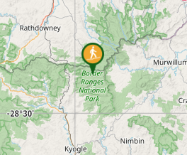
This National Park can be accessed from either Kyogle or Murwillumbah. Follow the signs from either the Summerland Way north of Kyogle via Wiangaree or the Murwillumbah-Kyogle Rd. The park is 38km west of Murwillimbah and 28km north of Kyogle. Brindle a Creek Picnic Area is located on a one way loop road between The Forest Tops Camping Area and The Pinnacle Lookout.
Maps
Which maps cover the area?
Route/Trail notes
Begin this walk at the Brindle Creek Picnic Area. To start with you follow the Brindle Creek Walk, but it branches off to the left where it crosses the Creek before taking you back to the road just down from the picnic area. The path is quite rough with lots of roots to step over, but there are narrow foot bridges over all watercourses so no need to rock hop.
Permits/Costs
THere is an $8 vehicle access charge per day
Other References
How can I find more info? Any guide books?
GPS Tracks
- No GPS available for this walk yet.


 1
1 30
30
Comments