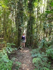
Go for a wander in the bush through Red Cedar loop and be rewarded with a grand finale. The scenic walking track leads you to the foot of a 48m red cedar tree. It’s a sight to behold and possibly 1000 years old. Look for epiphytes growing on the bark, such as bird’s nest fern, orchid and staghorn.
Cedars often grow close to creek lines, which made them easy pickings for the early European settlers who used flooded creeks and rivers to float the logs down to waiting ships and saw mills. This particular one was lucky enough to not be too close to the water’s edge.
Getting there
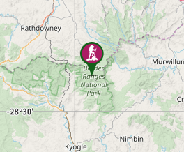
This National Park can be accessed from either Kyogle or Murwillumbah. Follow the signs from either the Summerland Way north of Kyogle via Wiangaree or the Murwillumbah-Kyogle Rd. The park is 38km west of Murwillimbah and 28km north of Kyogle. Brindle Creek Picnic Area is located on a one way loop road between The Forest Tops Camping Area and The Pinnacle Lookout.
Maps
Which maps cover the area?
Maps of Border Ranges National Park.
Route/Trail notes
THis walk begins across the road from the Brindle Creek Picnic Area and takes you through rainforest. The track divides to lead you around the loop to the foot of the red cedar. Follow the track round to complete the loop and back to the car par
Permits/Costs
There is an $8 per day vehicle entry fee.
Other References
How can I find more info? Any guide books?
https://www.nationalparks.nsw.gov.au/things-to-do/walking-tracks/red-cedar-loop
GPS Tracks
- No GPS available for this walk yet.


 750
750 20
20
Comments