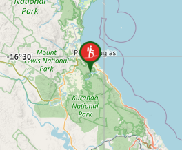
A steep but relatively straightforward walk that takes you from the Mowbray River Valley near Port Douglas to the Black Mountain Road.
Getting there
To access the start of the Bump Track, travel south from Port Douglas towards Cairns. About 2.5 km south of the main Port Douglas roundabout, turn right on to the Mowbray River Road, which will take you past the Glengarry Holiday Park. Continue 3.5 km along this road, paralleling the Mowbray River and crossing a small bridge to the start of the track.
Maps
A rough map can be obtained from the Queensland National Parks website here: https://parks.des.qld.gov.au/__data/assets/pdf_file/0022/163723/mowbray-np-bump-track.pdf
Route/Trail notes
***Take care on this track - you will be sharing it with mountain bikers!
The track follows an historic pack track up a steep spur, with occasional views of the valley and nearby coastline. The track passes through tall tropical rainforest, dropping down to cross the shallow Robbins Creek (head upstream a little to explore the pretty waterfalls), before continuing on to the Black Mountain Road. A short distance past the Robbins Creek crossing, a flagged path branches off to the right, while the main trail continues to Black Mountain Road. The branch path, not shown in the map, passes through more rainforest then descends very steeply to the Mowbray Falls, a great place for a swim and enjoy views down the valley. The round trip is roughly 13 km, with an altitude gain of 540 m along the track length, and should take 3-4 hours, longer if you intend to lounge in the pools near the top of the falls.
The track passes through the Mowbray National Park. As such, dogs are not permitted.


 The Bump Track (GPX)
 13.4
13.4 4
4
Comments
Nobody has commented on this walk yet. If you've done it then tick it off and add a comment.