Mt Mee Horse Trail - Dianas Bath

D'Aguilar National Park

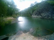
Follow the Mt Mee horse trail through a variety of forests to a stunning natural waterhole known as Dianas Bath.
This walk traverses two peaks, with a total rise and descent of 600m each way (so 1.2kms overall!!). The trail is loose weathered gravel and stones, is often very rutted and is quite slippery going up and much more slippery going down! The hills are between 15-29% gradients and quite long so you need to be very fit.
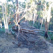
Much of the trail is overgrown with grasses and lantana, as well as the occasional fallen tree but the waterhole at the end is worth the walk, and definitely worth a swim!
Just after the first descent you cross Byron creek, which flows all year round and the rocks can be quite slippery. The water in this creek is a stunning shade of blue and crystal clear!

Start and end at the carpark just off Mt Brisbane rd - no messing around here - the walk immediately starts up to the peak of the first hill.

This walk should take between 7-10 hours with breaks dependent on your level of fitness and the state of the track.

Getting there

Drive straight through Dayboro and up to the carpark at the end of Mt Brisbane rd

Maps

The DERM Nt D'aguilar NP trail map is sufficient for this walk

Route/Trail notes

Surface very rocky, loose and rutted. Steep inclines and descents. Often overgrown with grasses as well as some trees down across the track. Rock hopping up the creek to the waterhole - rocks can be slippery. waterhole is an amazing place for a swim!

Please note that Dianas Bath is on private property. The owner currently allows walk-in access to the Bath from the National Park so for the sake of future access to this stunning waterhole, please keep this in mind. This means clean up any mess you make, take all litter with you, and respect anyone else who is using the waterhole. Last time we were there, we met friends of the owner who were enjoying a swim so you never know who is sharing the waterhole with you.

GPS Tracks

  • No GPS available for this walk yet.

Comments

Set out to hike to Diana's Bath from the Mount Brisbane Road car park. The hike as detailed, literally goes straight up! The ascents were tough, but definitely manageable if you take breaks as needed. I would recommend tackling this if have a good cardio fitness level (or if not just take your needed breaks) and are steady on your feet/have some good boots. I only make this recommendation as even with a good fitness level we found that the ascents (and descents) can be time consuming as they are so steep, as even though you are making ground you are mainly just going up/down. Be sure to bring lots of water, we found we went through water a lot quicker than anticipated due to the heat and physical exertion. We saw no other hikers, when we hit the dirt roads we did come across 4WD's, people on dirt bikes and a park ranger, who was kind enough to give us some more water! We didn't end up finding Diana's Bath as the track after the second ascent was closed so we started to walk the long way along the dirt roads and after getting past the 'Diana's Bath car park' and reaching the (dry) creek beds we had to turn back to ensure we would make it back before dark. I will upload a marked screenshot of the track we walked along and maybe it will help others, as we got a little confused as all the descriptions make it seem like you just keep following the horse trail and you will get there but there were quite a few times where we met a crossroad and sent someone ahead to check each of the options before choosing a direction to follow (crossroads that don't seem to appear on any of the maps!). We plan on heading back again soon to try and actually find Diana's Bath, would definitely be easier with a 4WD as you could drive straight down to 'Diana's Bath car park' as marked on the D’Aguilar National Park Mount Mee Forest Trail and Drive Map and then attempt to find your way from there (it's at the dead end road near the ending red dot on my marked screenshot map). Overall, we had a great day and despite not making it to Diana's Bath the creek crossing after the first ascent was really stunning and quite full. We didn't end up having to walk all the way back either because it started storming and a park ranger driving past on our walk back gave us a lift back to our car!

Astrid on 3 Jan, 2018

Great hike , love the long steep sections and if you have a good fitness level you can do this in 6 hrs ( including food/rest stop ) . Not as much lantana at the moment. Water looked too cold after a 9c night for a dip , just enjoyed the peace and quite, bliss !

J on 22 Jul, 2017

A lovely walk and worth the swim at the end. Bit of a scrub bash through lantana along Byron Creek till the walking track was found.

GlasshouseBW on 25 Sep, 2016

Trail to Diana's Bath is closed at the top of the second summit.

Steve on 1 May, 2016

Where

Click here to load this map.

Nearby Walks

Done this walk?

This walk has been ticked 12 times

Aussie Bushwalking can keep track of your bushwalks.

Login/signup to tick this walk off.

Tick walks to keep track of where you've been. You must Login to tick walks. Accounts are 100% free so sign up if you don't have one.