Mount Maroon Caves

Mt Barney National Park

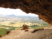
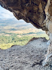
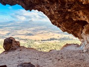
A walk up from Cotswold trailhead to a cave on the northern side of the mountain.

Off track bush-bashing and some climbing.

Lookouts
Scrambling or Climbing
Navigation Required
No Dogs Permitted
597m
Maximum Elevation
333m
Total Climb

Getting there

Start the usual place for Mount Maroon on Cotswold Road  

Maps

Best to find a trail on wikiloc that goes to the cave  

Route/Trail notes

After a few hundred meters of the usual summit track you need to head right (west) off the track. There are occasional cairns or white markers leading the way but it’s best to use wikiloc to not get lost.

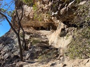
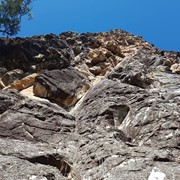
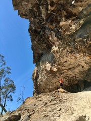
You’ll come to the bottom of the huge cliffs which you follow west until you get to the cave. Be extra careful around this part since there’s a high risk of rock fall 

Permits/Costs

None 

Other References

See https://www.wikiloc.com/hiking-trails/mt-maroon-up-nth-west-via-cave-32338485 which also shows a way to get from the cave to the summit - which is much harder than the usual track 

Comments

Embarking on the climb up Mt Maroon is a wild ride that's equal parts challenging and exhilarating. Right from the start, you're faced with steep inclines that really put your endurance to the test. Make sure you limber up before hitting the trail, because you're gonna need all the strength you can muster. And don't forget to pack loads of water to keep yourself hydrated under the sun.

But hey, despite the tough climb, the trail is pretty well-marked, so you'll feel pretty secure as you make your way up. Just watch your step in the tricky spots, especially with those big boulders strewn about. Oh, and here's a heads up: getting to the trailhead ain't a cakewalk. You definitely need a 4WD or Suv to tackle the rough terrain; trying it with a regular car is just asking for trouble. Plus, parking. Yeah, that's a bit of a hassle too. Unless you've got a decent 4WD, you might struggle to find a spot.

And here's a tip: if it's raining, think twice about driving up there without 4WD. The dirt track turns into a slippery mess of clay and rocks, and you don't wanna risk getting stuck. But hey, despite all the challenges, reaching the top of Mt Maroon is totally worth it. The views are breathtaking, and the feeling of accomplishment? That's unbeatable. So grab your gear, buckle up, and get ready for one heck of an adventure!

Louise Chauvier on 19 May, 2024

The most challenging part is not the hike itself but the fact that the track disappears many times along the way as this hike is obvisuly less used compared to the Summit walk which has a clear track you can follow.
Make sure you have some sort of GPS with you or you will never make it without one.
Caves are really cool and worth the effort

Jozef KESEG on 9 Sep, 2023

Did this one with my 11 year old son, he was keen to do the loop up to the summit and back down the main track, was a big day, slippery in spots and not much of a track to speak of.

samkramer on 17 Jun, 2023

Downloaded a track that turned out to be a line on a map. There was no track, just hard slog bush bashing. I didn’t think the views from the caves were any more spectacular than those from the summit. I think there may be another, easier, track further up the trail than the one I used, that just goes to the caves and back. The scramble up the western end was quite challenging but rewarding. Next time I think I’ll just go up and back on the official trail!

Olwyn on 20 Jun, 2021

The view never gets old from the cave for me no matter how times i've been there. Really shouldn't be attempted without a GPS trail to follow as there is no real trail and quite easy to lose again when you do find the bits that are there.

Chewie on 29 May, 2021

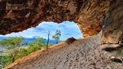
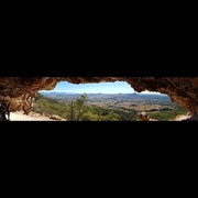
Completed this walk yesterday with a friend and the view from the cave is nothing short of spectacular. We got a bit lost after missing some important markers and our gps trail, but soon found our way back to where we needed to be on the trail we were following. But we did find some incredible rock formations and photo ops we wouldn't have otherwise got.
Despite weather reports of it being really hot, we started the trek around 7am and took 2 hours to get to the cave. Beautiful breeze the whole time while on the mountain kept the heat down. Spent around an 1 hour in the cave and then an hour back down again.
We rebuilt a few rock cairns and made an additional couple in spots we missed on the way in for our's and other people's references.

Chewie on 6 Dec, 2020

Done the track to the caves only. Worth going, but follow the wikilocs track. You will.find cairns and white bands along the trail.

ovel on 5 Sep, 2020

What an epic trail!!! We did the cave route today, getting to the caves was pretty easy. There aren't any clear trails so you will need either Wikiloc or equivalent, or someone who has done it before. The caves are the easy part. The hard part was what came next if you want to do a summit push...

We went for the summit via the west ridge. There are even less trails to follow going that way. Definite bush bashing on this route. Lots of spiders and loose rocks and leaf litter making for some sketchy situations. Navigational skills are strongly advised in case your phone dies and you are alone.

Also when traversing along the rock wall below the cave, be careful for rock climbers above.

Nittus on 19 Jul, 2020

Not too hard to find the cave and great views once you get there. The cave to the summit was a lot more challenging navigationally! We used a GPS track from alltrails.

Heather T on 23 May, 2020

Great walk. Lost the track several times but then you would see a cairn and be okay. Ended up downloading a Wikiloc at one point and used that as a guide. The cave was amazing and so worth the trek.

Sheridan on 31 Aug, 2019

Great views from the cave. Faint track but easy to get sidetracked. Pretty tough just to the cave and going to the summit from the cave was too tough for me solo today.

Juiced Pixels on 9 Feb, 2019

Where

Click here to load this map.

Nearby Walks

Done this walk?

This walk has been ticked 42 times

Aussie Bushwalking can keep track of your bushwalks.

Login/signup to tick this walk off.

Tick walks to keep track of where you've been. You must Login to tick walks. Accounts are 100% free so sign up if you don't have one.