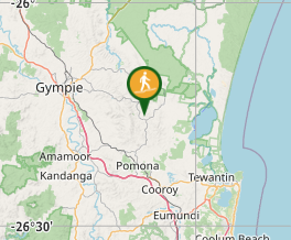
Travel to Kin Kin. The walks starts in the centre of town.
Maps:
https://www.noosa.qld.gov.au/noosa-trail-network
Route/Trail notes:
See network map on above website
Permits/Costs:
None.
Other References/Comments:
How can I find more info? Any guide books?
GPS Tracks
No GPS available for this walk yet.
Comments
really lovely walk to do but definitely recommend bringing a hat and having a decent amount of water. i stopped a few times and interacted with some cows and horses which was lovely so the walk took me about 3.5-4 hours. Be prepared for a lot of long uphill parts other than that very therapeutic. Expect to go through a lot of gates, very well marked too. I would love to go again but with someone.
This was a lovely stroll. We particularly enjoyed the sections which passed through fields and forest. Lots of animal encounters - cows, horses, wallabies, sheep, donkeys, and even a pair of miniature dachshunds keeping watch over one of the many gates. Definitely a winter walk as it is quite sun exposed for the majority of the way.
This was a lovely walk in the country. We did the walk in a clockwise direction, so the hardest part was first. We began at the carpark at the opposite end of town to the pub, opposite the public toilet. The first part was quite hilly. We had two problems along the way. The first was that there was a large bull with two cows and a calf in the last paddock we were to cross. They were close to where we needed to walk too, so we decided to jump the fence and walk past in the adjoining paddock rather than upset the bull. The next problem we had was after this paddock, we followed the sign in the direction it seemed to indicate (which was also in the direction we know we needed to go. I have to say it was probably against our better judgement. It led down to the road via a really steep hill that looked like it had been freshly graded. A young agile person may not have a problem, but we're not that. It was really quite dangerous. There was a proper track from the top that went in the opposite direction, and we probably should have taken that. Once we got down to the road the signs seemed to disappear, indicating that we had probably gone the wrong way. We followed the main road back to Kin Kin - not too far, and just before we arrived at the turnoff to the town there was another sign, so we knew we hadn't gone too far off the track. All in all we would recommend this walk, but probably as a winter walk. It could get quite hot in summer.
A really lovely ramble through the countryside. Pick a sunny winter day and make sure to stop in to the Kin Kin Country Life pub afterwards for a beer. We did the walk clockwise, the first and last sections were the most undulating. The Wahpunga Lane and Bunney Lanes sections are along quiet country roads but the rest of the walk traverses private properties - you will go through a LOT of gates. There are rest shelerts at Gradys and Shepparsons, and a portaloo toilet at Shepparsons (needs maintenance at the moment though). The very thoughtful TR and NJ Grady have put a table and chairs outside their property at 223 Wahpunga Lane which is about the half way mark - thank you very much!
Strava said this walk was 16km not 14 but mostly flat so it is pretty easy to complete in 4 hours walking fairly slow. Only a couple of hills and not steep but it was very boggy after rain. Charming walk in the countryside
Navigation to some bushwalks can be difficult. Automated navigation using Google Maps or Apple Maps may not be accurate.
Additionally, Aussie Bushwalking doesn't always have accurate positions for where to park for a walk.
Please read the walk description for special directions and take extra care.
Medium
14kmreturn
3.5hrs
These values are provided by users. Your evaluation may differ.
Comments