
Mount Field West & Naturalist Peak
Mount Field National Park


Menu
A long walk to the heighest peak in Mount Field National Park. The hut at K Col has some good history and theres also the chance to go slightly off the main trail to summit the Rodway Range and Naturalist Peak.

Getting there
How do you get to the start of the walk?
Lake Dobson Carpark at the end of Lake Dobson Rd
Maps
Which maps cover the area?
Maps of Mount Field National Park
Route/Trail notes
A detailed description of the walk!
From Lake Dobson take the Urquhart Track and Snowgum Track up to the top of the ski field then continue on past the Tarn Shelf turn off to the top of the Rodway Range (you need to scramble slightly off the main trail to get to the summit). The trail then heads down the far side of the Rodway Range to K Col and its hut which has interesting history. Then pass Clemes Tarn up onto the high plateau between Naturalist Peak and Mount Field West. It is stunning up here. Take the off trail scramble up to Naturalist Peak then return to trail and head over to Mount Field West and then return the way you have come.
Permits/Costs
Do you need any permits? What's the cost?
Free if you already have your park pass
Other References
How can I find more info? Any guide books?
GPS Tracks
- No GPS available for this walk yet.
 18.4
18.4 1
1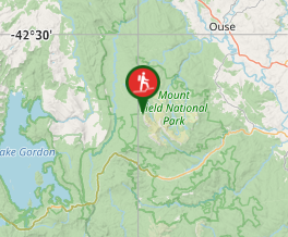
Comments
Nobody has commented on this walk yet. If you've done it then tick it off and add a comment.