


 7
7 2
2- Wickham Peak - Calytrix Circuit (Wickham Timber Reserve) (South East Queensland)
- Wickham National Park High Point (South East Queensland)
- Small Cave (Plunkett Conservation Park) (South East Queensland)
- Melichrus Trail (Plunkett Conservation Park) (South East Queensland)
- Veresdale Walk (South East Queensland)
Birnam Range
South East Queensland
Menu
Walk along the spine of the Birnam Range. The trail along the range stretches for 7-8kms starting in the South from the end of Monmouth Ct or the main Mundoolun Road and finishing in the North at Currawong Ct. Outlined in this walk is a section of the trail along the highest part of the range starting from and returning to Mona Dr which is one of a few additional enterance points.
Lookouts
Eucalypt Forest
243m
Maximum Elevation
299m
Total Climb
Getting there
How do you get to the start of the walk?
Many access points as described in overview although as outlined here this walk starts at Mona Dr.
Maps
Which maps cover the area?
Maps of Birnam Range
Route/Trail notes
A detailed description of the walk!
From Mona Dr walk the short trail up onto the spine of the Birnam Range and turn left. You shall now be heading roughly Northeast up the spine of the range to its highest point. Once reached retrace steps.
Permits/Costs
Do you need any permits? What's the cost?
Free
Other References
How can I find more info? Any guide books?
GPS Tracks
- No GPS available for this walk yet.
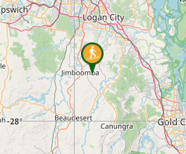
Where
Click here to load this map.
Comments
Nobody has commented on this walk yet. If you've done it then tick it off and add a comment.