


 3.8
3.8 90
90- Melichrus Trail (Plunkett Conservation Park) (South East Queensland)
- Windaroo Mountian (Brisbane City Council Local Walks)
- Small Cave (Plunkett Conservation Park) (South East Queensland)
- Wickham National Park High Point (South East Queensland)
- Wickham Peak - Calytrix Circuit (Wickham Timber Reserve) (South East Queensland)
Davis Hill
South East Queensland
Menu
A short walk which climbs gradually along fire trail to the summit of Davis Hill (298m). Views from the summit are limited, and there is a communications mast at the top.
Bird Watching
Navigation Required
No Dogs Permitted
No Horses Permitted
No Cycling Permitted
No Camping Permitted
Eucalypt Forest
298m
Maximum Elevation
160m
Total Climb
Getting there
How do you get to the start of the walk?
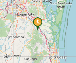
The walk starts from the end of Vennor Drive, Ormeau Hills. From the M1, take exit 45 onto Peachey Road, then turn left onto Vennor Drive and continue all the way to the end.
Maps
Which maps cover the area?
Route/Trail notes
The trail rises gradually through open eucalypt forest to the summit of Davis Hill (298m). Views from the summit are limited, and there is a communications tower located at the top.
Permits/Costs
Do you need any permits? What's the cost?
Other References
How can I find more info? Any guide books?
GPS Tracks
- No GPS available for this walk yet.
Where
Click here to load this map.
Comments
Nobody has commented on this walk yet. If you've done it then tick it off and add a comment.