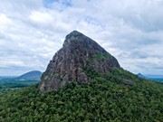
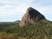
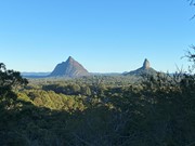
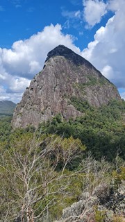
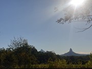
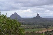
At just 167m, this is probably the least climbed and one of the least known mountains in the area, especially as it is overshadowed by Mount Tibrogargan immediately to the west.

Lookouts
Scrambling or Climbing
No Dogs Permitted
No Camping Permitted
Eucalypt Forest
167m
Maximum Elevation
127m
Total Climb

Getting there:

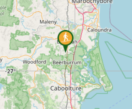
Turn off the Bruce Highway onto Steven Irwin Way and just north of Beerburrum turn into Barrs Road, which is signposted for access to Mt Tibrogargan. The fire trail access is on the left opposite 210 Barrs Road. Park where you can.

Maps:

Glass House Mountains

Barrs Road is marked, but not Mt Cooee.

Route/Trail notes;

Start from the National Park gate on Barrs Rd and walk along the “fire trail” for 500m to the 'T' junction. There  are now at least four options open to you, all requiring a bush-bash to the top:

1) Go straight ahead.

2) Turn left and after 300m head east to the top.

3) Turn right and after 800m, when you reach the cleared agricultural land and dam, turn north west to the top.

4) Go beyond this point and follow the power lines to the top of the ridge. You will have to go back into the trees at some points as the gullies along the power line track are too dense to get through. At the top of the ridge, turn left and fight your way to the top.

Due to vegetation at the summit there are limited view so have a look around, but be careful, as the shrub can hide cliffs.

Permits/Costs:

None

Other Comments:

The fire trails and scrub on the mountain have not been maintained (2016) or 'back burnt' and looks like an accident waiting to happen as it is all timber dry and what has been cut down along the fire trail no longer provides a fire break.

GPS Tracks

Comments

Finally climbed this last of all the GH mountains (excluding Coonowrin) after many years. Shorter than expected and worth some decent views of the other mountains.

JayWalker on 16 Mar, 2024

Took the "straight up" route using the path of least resistance, saw two pink flags on the way but no other markers. Took roughly 40mins to get to the top. When I say "top" we made it to 160m elevation so 7m off the top but the bush became very thick so we didnt proceed further. Not quite a bush bash but pretty close, recommend wearing a jacket to avoid cuts from bushes/stalks. Was a nice little hike with an awesome view of Mt Tibrogargan. Small amount of fun rock scrambling but nothing too intense. Rock was a little slippery from the rain the past couple days but felt prettt safe.

Sianlesley on 3 Jul, 2022

I couldn't find actual path, but it is a great walk and it give you a lot of freedom. 100% will do it again

Dominik on 22 Jan, 2022

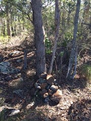
The track was fairly easy to follow. I did lose it on the way up but just walked through the bush and found the rock cairn that indicated the summit.

A bit more wandering and I found a great spot to view Mt tibrogargen just next to it I found the trail again and got down very easily.

Some slippery patches of rock from the rain. Nothing to bad though.

Alot like Mount Miketeebumulgrai but with great views!

Mitchell Biggs on 11 Nov, 2021

Fairly straightforward walk up, great views of Tibro up close & Beewah etc further to the west

Bribie 61 on 3 Oct, 2021

Parking where you can of the Fire Trail sign, you'll get to a T Junction, go straight into the trees you'll see pink ribbon to almost the top, little bit of climbing, though a real nice view, you'll eventually go to a park after the view where it's denser with trees, the ribbon ends you gotta find your way bush bashing through.

Lotus on 14 Aug, 2021

Fun little hike. Took the ‘straight ahead’ route which is straight through the trees. The entrance is a little hard to see at first but if you look through the trees you should see pink tape ahead. Some nice views on the way up and some fun little scrambles. The rock surface is quite rough and ‘grippy’ and the incline not very steep.

Olwyn on 5 Jun, 2021

I delayed summitting Mount Cooee for a year or two after reading the comments, as I expected the hike and climb up to be alot worse than it was.

We didn't park close to the fire trail, as there was no good spots to park close.

Follow the fire trail. When I got to the T junction, I chose the way that was straight ahead, and I followed the pink ribbon trail (pink ribbons tied to trees), which took you 90% of the way to the summit. This trail had multiple spots with really nice views, and there's a really nice rocky area to sit with the views and have some food/drinks and relax. While following the pink ribbon trail, I didn't get scratches or plants brushing up against me much. The trail was good, it included some fun rock scrambling. The last bit was not marked with the pink ribbons on trees, and thick plant life that will scratch you has grown over every possible way to reach the summit. Still, I wanted to summit, and I'm glad my husband didn't, as I relied on his voice to find my way back to the trail. I recorded my path to the summit on the All Trails app.

Bring mosquito spray, they were so hungry they were biting me through my tights. This took us only 1 hr of moving time (and we definately weren't going fast) plus some more time to admire the views, and take photos. There were a few times we thought the pink ribbons had ended, but then look further/ walk a bit more then you'll see it.

This hike isn't popular, so we walked through some spider webs that wouldn't be there if there had been more people going up this way. I only saw small spiders.

I've been using the word "trail" whereas others would disagree and call it a bush bash, but in my mind, bush bashing is alot worse than what we did.

Recording your hike on the All Trails app helps you find your way to the summit, as the mountains topography is shown on there.

Hannah MC on 17 Apr, 2021

So the description is accurate, after you get off the firetrail it is pretty close to trackless. There are some faint markings, and there is a rough track running across the top, but for the most part you just have to make your own way up and down. There are some nice views on the North Eastern side out towards Mt Beerwah. It's a lot like mt miketeebumulgrai, except slightly worse in the track department, and slightly better in the view department.

Vonsnrub on 19 Sep, 2020

Did this climb yesterday, could not find any tracks, so just bush bashed my way to the top, enjoyed the view over the quarry and Bribie Island.nice to have the mountain to myself, great views of Tibro on the way down on the western side,
But would no be in a hurry to do it again, legs pretty scratched on the way up, lantana very thick,,no clear tracks makes for dangerous trip on the way down

Steve H on 19 Jun, 2019

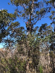
Lots of Lantana and plants that what to scratch you and swallow you up. Not a defined track but still pretty cool to go somewhere away from all the crowds. Once you get to the summit you might wanna climb a tree to get a better view lol!

Paul on 29 Aug, 2018

You thought it was scrubby before. Try it know. Loads of trees have fallen along the entire length of the fire trail. It's exhausting climbing over, around and under them. The mountain itself was scrubby and trackless. I did quite a lot of track marking with arrows on rocks and building rock cairns. As well as clearing branches.
Was a lot easier to come down following my track.
Although there are know views from the top. There are very good view of Tibros north face on the way up.

Pardo on 2 Jul, 2017

This has got to be the most frustrating mountain to climb in the Glass House Mountains. There is no trail as such and you bush-bash your way to the top and back again the best way you can. There is no view at the top and you come home covered in scratches; but you just ticked off another climb!

We started our own cairn to mark the top.

F.A.B. on 30 Jul, 2016

Was initially confused as to the location of the access point. The fire trail is marked but easy to miss and is located approximately opposite number 210 on Barrs Road, which is the last house on the right before the main Tibrogargan car park when travelling westwards from Steve Irwin Way.

Fire trail was easy enough but full of a horrible type of grass that got stuck in my socks like needles. After 500m fire trail forked in a T junction, however access to the trail on the right was restricted - big warning sign about it. There was a marked path with pink ties leading directly ahead through the bush, however. The path took me about half way up the mountain before disappearing. The rest of the way was path of least resistance, and it should be noted the bush was pretty thick and fairly unpleasant and left no view from the summit. Came out with a lot of scratches, and had to double back several times on the way back down.

MDWL on 9 Apr, 2016

Scrubby

balri on 11 Mar, 2016

Couldn't find track. Made our own. Easy but scrub all over

smitsie on 26 Sep, 2015

No track.. basically bush bashed our way to the summit! Plenty of scratches! Watch for snakes in the warmer months!

kyles36 on 26 Sep, 2015

Followed instructions but did not find water tank. Came out at a dam on North East corner of Tibro. Turned left (north) and followed powerlines to top of ridge where I could look down and see Barrs Rd on the other side of a pineapple plantation. I turned sharp left and scrub bashed my way west then south then west then south until I eventually found myself at the highest point. There are no rock cairns to mark the summit. From here I continued south for a couple of hundred metres weaving around to avoid the worst of the undergrowth. Eventually I came out on an open verge, not exactly a cliff face but a clear view of Tibro. I then weaved my way in a generally south west direction down some exposed rock faces (not very steep) and rejoined the fire management trail just before the fork in the track as described in the previous track notes. Total distance 3.7km. Elevation gain 150m. Time 1hr 25minutes.

Grumps on 31 Jan, 2014

Where

Click here to load this map.

Nearby Walks

Done this walk?

This walk has been ticked 55 times

Aussie Bushwalking can keep track of your bushwalks.

Login/signup to tick this walk off.

Tick walks to keep track of where you've been. You must Login to tick walks. Accounts are 100% free so sign up if you don't have one.